
In today’s rapidly evolving technological landscape, the use of LiDAR (Light Detection and Ranging) technology has gained considerable attention. But can LiDAR detect landmines, one of the most elusive and dangerous threats in conflict-ridden areas? This article delves into the intriguing world of LiDAR technology and its potential to unearth landmines, providing a comprehensive overview of its applications, challenges, and prospects.
Absolutely, LiDAR can detect landmines. Using laser pulses, LiDAR creates detailed 3D maps of the terrain, revealing irregularities caused by buried landmines. Its precision and non-invasive nature make it a promising tool in the fight against this hidden threat.
Can LiDAR Detect Landmines?
LiDAR, which stands for Light Detection and Ranging, is a cutting-edge technology that uses laser pulses to measure distances with exceptional accuracy. Its applications have expanded beyond mapping and autonomous vehicles to include landmine detection.
The Challenge of Hidden Landmines
Landmines pose a severe threat to civilian populations in conflict-affected regions. These hidden explosives can remain active for decades, causing casualties and hindering development efforts. Traditional landmine detection methods are often slow and dangerous, requiring manual demining teams to risk their lives.
LiDAR’s Unique Advantages
LiDAR technology offers several advantages in the quest to detect landmines:
- High Precision Mapping: LiDAR can create detailed 3D maps, allowing it to identify irregularities in the terrain caused by buried landmines.
- Speed and Efficiency: LiDAR surveys large areas quickly, making it a cost-effective and time-efficient solution.
- Non-Invasive: Unlike traditional methods, LiDAR does not require physical contact with the ground, reducing the risk to demining personnel.
- Versatility: LiDAR can be mounted on various platforms, including drones and vehicles, enhancing its adaptability.
LiDAR vs Other Detection Technologies
To gauge LiDAR’s effectiveness in landmine detection, it’s essential to compare it with other technologies such as Radar, Sonar, and Photogrammetry. Each of these methods has distinct advantages and limitations in different environments. For example, while radar is effective in penetrating deeper ground layers, it may not provide the same level of detail as LiDAR. Similarly, sonar is primarily used for underwater applications and might not be suitable for land-based mine detection.
Exploring LiDAR’s Technical Capabilities in Landmine Detection
LiDAR technology’s precision in generating high-resolution images is pivotal in detecting landmines. Its ability to map terrain with great detail can potentially reveal disturbances or anomalies indicative of buried landmines. However, the efficiency of LiDAR in this application is influenced by various factors:
- Soil Composition: Different soil types affect LiDAR’s penetration and imaging capabilities.
- Depth of Mines: The effectiveness of LiDAR diminishes as the depth of the object increases.
- Surface Cover: Dense vegetation or other surface cover can impact the accuracy of LiDAR data.
Comparative Analysis: LiDAR vs. Related Technologies
A comparative analysis of LiDAR with similar technologies such as Radar and Laser reveals distinct advantages and challenges:
- Radar: Offers deeper ground penetration but may lack the detailed resolution of LiDAR.
- Laser: Similar in operation to LiDAR but might have different applications and range capabilities.
- Photogrammetry: Offers surface-level imagery but lacks the subsurface mapping capabilities of LiDAR.
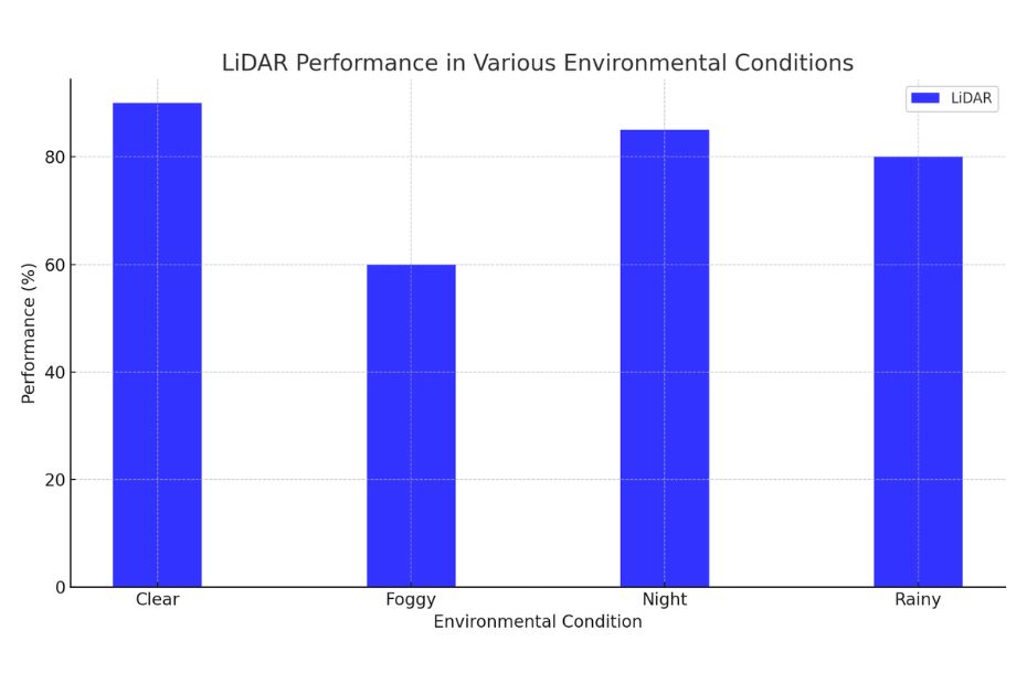
LiDAR’s Effectiveness in Different Environments
LiDAR’s performance in various environmental conditions is a critical aspect of its applicability in landmine detection:
- Night Operations: LiDAR’s effectiveness at night Does LiDAR Work at Night? remains consistent, owing to its reliance on laser light rather than natural light.
- Foggy Conditions: The capability of LiDAR to operate in foggy conditions Does LiDAR Work in Fog? can be limited, as fog can scatter the laser beams, reducing image clarity.
LiDAR’s application in landmine detection is a beacon of hope in the realm of post-conflict recovery. Its ability to provide accurate terrain data, coupled with its adaptability in various environmental conditions, positions it as a valuable tool in the ongoing efforts to make former conflict zones safer.
LiDAR’s Future in Landmine Detection
The integration of LiDAR with other spatial technologies like DEM (Digital Elevation Models) and advancements in sensor technology could greatly enhance its application in landmine detection. As research continues, LiDAR could become an integral part of an interdisciplinary approach to safely and efficiently detect landmines.
Conclusion:
In the ongoing quest to eliminate the threat of landmines, LiDAR technology emerges as a potent tool. Its ability to provide high-precision mapping and its non-invasive nature make it a promising solution. However, challenges such as false positives and environmental factors must be addressed for widespread adoption.
FAQs: Can LiDAR Detect Landmines?
Can LiDAR detect all types of landmines?
LiDAR can detect various types of landmines, but its effectiveness may vary depending on factors like the landmine’s depth and the terrain.
Is LiDAR-based landmine detection cost-effective?
While the initial investment in LiDAR technology can be substantial, its speed and efficiency can make it cost-effective in the long run, especially for large-scale demining operations.
How accurate is LiDAR in detecting landmines?
LiDAR can provide highly accurate data, but its accuracy in detecting landmines depends on various factors, including the equipment used and environmental conditions.
Can LiDAR detect landmines in waterlogged areas?
LiDAR’s performance can be compromised in waterlogged conditions, affecting its accuracy.