
In the ever-evolving world of technology, the battle for supremacy often revolves around innovations that promise to reshape industries. Among these innovations, LiDAR and Sonar have emerged as pivotal players in the realm of sensing technologies. In this comprehensive guide, we delve into the fascinating world of LiDAR and Sonar, comparing their strengths, applications, and impact on various industries. So, grab your snorkel and prepare to dive deep into the Lidar vs Sonar showdown.
LiDAR uses laser light to measure distances and create detailed 3D maps on land, while Sonar relies on sound waves to detect objects underwater. In essence, LiDAR is for terrestrial applications, while Sonar excels in underwater environments.
LiDAR vs Sonar
This article aimed to provide a comprehensive overview of LiDAR versus Sonar technologies, their applications, technical aspects, user experiences, and their environmental and economic impacts.
Understanding the Basics
What is LiDAR?
LiDAR, which stands for Light Detection and Ranging, is a remote sensing technology that uses laser light to measure distances and create highly detailed, three-dimensional maps of objects and environments. It operates on the principle of emitting laser pulses and measuring the time it takes for the light to bounce back after hitting an object.
What is Sonar?
Sonar, short for Sound Navigation and Ranging, is a sensing technology that relies on sound waves to detect objects underwater. It works by emitting sound pulses and measuring the time it takes for the echoes to return, providing information about the location, size, and shape of objects in water.
Comparing LiDAR and Sonar: Where They Thrive
LiDAR’s ability to provide precise data in clear conditions is balanced by its limitations in cloudy or foggy environments. Similarly, while Sonar excels underwater, it is ineffective on land. Considering these operational environments is crucial when choosing between the two for a specific project.
| LiDAR | Sonar |
|---|---|
| Excellent for land and atmospheric data. | Best suited for underwater exploration. |
| High accuracy in vegetation penetration. | Ideal for depth measurement in oceans. |
| 3D modeling of surfaces and landscapes. | Efficient in mapping seabed and underwater habitats. |
Integration and Overlap: A Collaborative Approach
Despite their differences, LiDAR and Sonar can be complementary. In coastal mapping, for example, LiDAR can detail the land-water interface, while Sonar maps the underwater topography, providing a seamless profile from terrestrial to marine environments.
For a deeper dive into LiDAR and its comparison with similar technologies, consider exploring “LiDAR vs Photogrammetry” and how these methodologies differ in processing and results.
Technical Intricacies: LiDAR and Sonar Precision
LiDAR systems, with their reliance on the speed of light, boast incredible precision, typically measuring distances within a few centimeters’ accuracy. This precision is fundamental in applications such as self-driving cars, where safety and efficiency are paramount. Furthermore, advancements in LiDAR technology have led to the development of smaller, more affordable units, expanding its accessibility and use cases.
On the flip side, Sonar’s use of sound waves means its accuracy is affected by factors such as water temperature, salinity, and pressure. Despite this, Sonar remains the go-to technology for underwater applications because radio waves — the basis of radar and LiDAR — attenuate quickly in water, making them unsuitable for this environment.
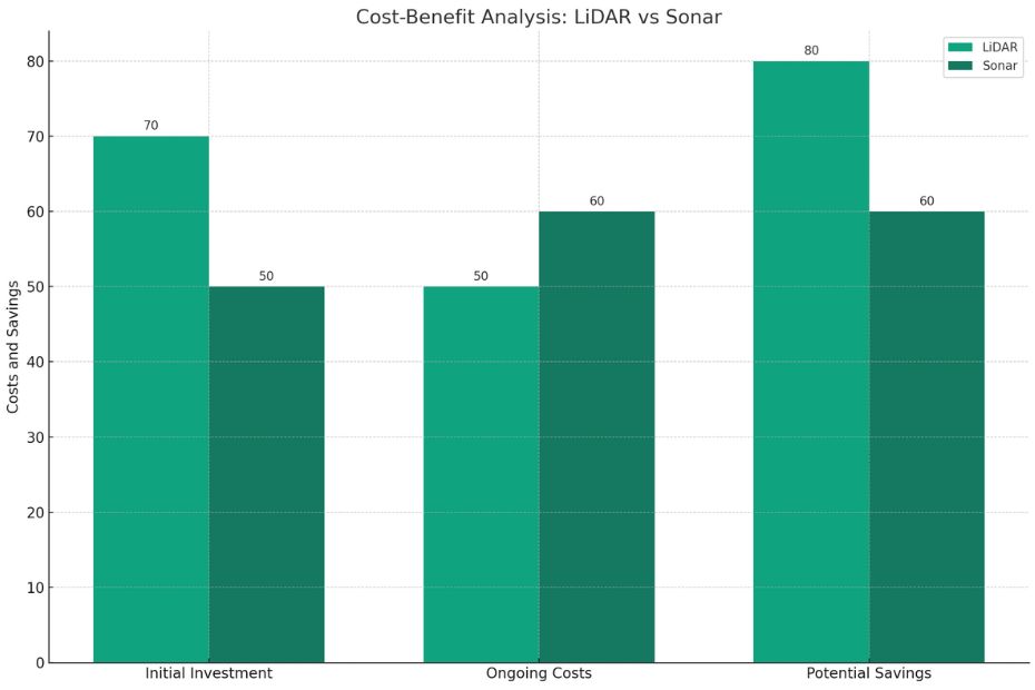
Cost Considerations: Investment and Return
When it comes to costs, LiDAR’s initial investment is high, but the breadth of data it provides can lead to substantial savings over time, such as reduced need for on-the-ground surveys. Sonar, while generally less expensive, may incur additional costs in data processing and interpretation.
| Technology | Initial Investment | Ongoing Costs | Potential Savings |
|---|---|---|---|
| LiDAR | High | Moderate | High |
| Sonar | Moderate | High | Moderate |
Environmental and Physical Limitations
While LiDAR is less effective in poor visibility conditions such as fog, rain, or snow, it excels in daylight and clear weather. Sonar isn’t impacted by visibility but requires a medium like water to function, limiting its use to aquatic environments.
Advantages and Limitations
LiDAR Advantages
LiDAR boasts several advantages:
- High Precision: It provides incredibly accurate measurements, making it suitable for detailed mapping.
- Non-Invasive: LiDAR doesn’t require physical contact with objects, reducing the risk of damage.
- Versatility: It can be used in various environments, including forests, cities, and deserts.
However, it does have limitations, such as cost and sensitivity to weather conditions.
Sonar Advantages
Sonar, too, has its own set of advantages:
- Penetrating Power: Sound waves can penetrate water effectively, enabling deep-sea exploration.
- Cost-Efficient: Sonar systems are generally more affordable compared to LiDAR.
- Reliability: They are less affected by adverse weather conditions.
Yet, sonar’s accuracy may be compromised in certain scenarios, and it’s not suitable for terrestrial applications.
Future Developments: Pushing the Boundaries
The future of LiDAR and Sonar is bright, with ongoing research pushing the capabilities of both technologies. LiDAR is seeing innovations that reduce its size and power consumption, making it more suitable for integration into various devices. Sonar technology is also advancing, with improvements in signal processing algorithms enhancing its resolution and object differentiation capabilities.
Conclusion:
In the battle of sensing technologies, both LiDAR and Sonar have their unique strengths and applications. LiDAR excels in terrestrial environments, offering precision and versatility, while Sonar dominates underwater, providing cost-effective solutions. The choice between the two ultimately depends on the specific needs of the industry or project at hand.
FAQs: LiDAR vs Sonar
Which is more accurate: LiDAR or Sonar?
LiDAR tends to offer higher accuracy for terrestrial applications, while Sonar excels in underwater environments.
Are LiDAR and Sonar used together in any applications?
Yes, some applications, such as underwater archaeology and marine research, may involve the use of both LiDAR and Sonar for comprehensive data collection.
Can LiDAR be used for underwater mapping?
LiDAR is primarily designed for terrestrial mapping and may not perform optimally underwater.
What industries benefit the most from Sonar technology?
Industries related to marine navigation, fisheries, and oceanography derive significant benefits from Sonar technology.
How do weather conditions affect LiDAR and Sonar performance?
LiDAR can be sensitive to adverse weather conditions, while Sonar is generally more robust in such situations.
