
Longitude and latitude lines are fundamental components of the geographic coordinate system that helps us understand and navigate the Earth’s surface.
These imaginary lines form a grid system that allows us to pinpoint any location on our planet. In this article, we will explore the concept of longitude and latitude, their individual characteristics, and the vital role they play in various fields.
In the past, finding longitude or latitudes was a difficult task that required a lot of time and calculation. However, with the advent of GPS technology, it is now really easy to know your exact coordinates.
What are Longitude and Latitude Lines?
Latitude lines are vertical lines on a map that are parallel to the Equator. They are perpendicular to lines of longitude.
Longitude lines are horizontal lines on a map that are parallel to the Prime Meridian at Greenwich, England. They are perpendicular to parallels of latitude.
To know more in brief below are the complete details of Longitude and Latitude Lines.
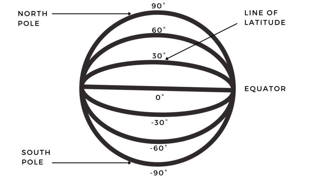
What is Latitude?
Latitude is measured in degrees. It is expressed by a decimal number with a degree sign after it, for example, 40°N or -27°S. Latitudes are said to be “north” or “south” of the equator depending upon their orientation in relation to it. The further north or south you go, for instance, 100°N or 100°S respectively, the greater your latitude value becomes.
What is Longitude?
Longitude lines are the imaginary lines running from the North Pole to the South Pole, with 0 degrees of longitude being at Greenwich in England. Similarly, latitude lines are imaginary lines running from the equator to both poles, with 0 degrees of latitude being at the equator.

Comparison: Latitude vs Longitude
Here is the comparison between Latitude vs Longitude Lines:
Comparison | Latitude | Longitude |
Directions | East To West | North To South |
Parallel Lines | Yes | Not Parallel |
Number of Lines | 180 | 360 |
Ranges | 0 to 90° | 0 to 180° |
Symbol | ɸ (phi) | λ (lambda) |
Classifies | Heat Zone (Temperature) | Time Zone |
Length of Lines | Different | Same |
Notable Lines | Equator, Tropic of Cancer, Tropic of Capricorn | Greenwich Meridian |
Meridians and Parallels
A Meridian is a line of longitude on the Earth’s surface. It is an imaginary line running around the Earth from the North Pole to the South Pole, passing through both poles. A meridian is a north-south axis of a sphere whereas a parallel can be north-south or east-west.
The Northern and Southern Hemispheres are divided by longitudinal meridians whereas parallels are used to divide each hemisphere according to their latitude ranges.
A Parallel is a circle of latitude on the planet’s surface. It is an imaginary circle around the Earth that passes through both poles and has its centre on or near one of the poles.
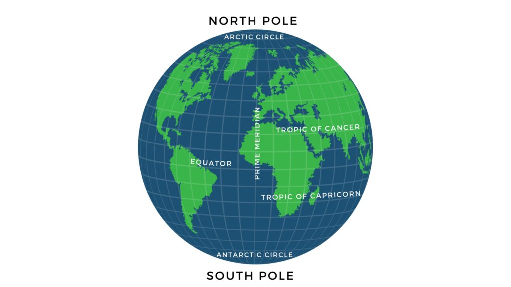
Where is the Equator?
The equator is an imaginary line around Earth, dividing the earth into a northern and southern hemispheres. It is located at 0° north or south latitude on the Earth’s surface.
Where Is The Tropic of Cancer Located?
The tropic of cancer is located on the equator at 23.5 degrees North. The earth’s tilt of 23.5 degrees on its axis causes this phenomenon to happen, due to the sun’s position in relation to the earth during different seasons of the year.
Tropic of Capricorn Degrees
The Tropic of Capricorn is a circle of latitude that defines the most southerly point at which the sun may appear directly overhead at its zenith. It is situated about 66 degrees south of the Equator, and it passes through southern Africa, where it crosses from east to west.
In South Africa, the Tropic of Capricorn falls on December 22 each year – this is known as the “summer solstice for the southern hemisphere”.
Where Is The Arctic And Antarctic Circle Location?
The arctic circle is an imaginary line that marks the northernmost point of the sun’s annual migration. The arctic circle is located at 66.33 degrees north latitude and it marks the northernmost point on the Earth where the sun can appear directly overhead at noon on December 21st.
The antarctic circle is a similar imaginary line, but it marks the southernmost point of the sun’s annual migration.
What Is Prime Meridian Line?
The prime meridian is the starting point for time zones around the world. It originates from Greenwich, England.
The Prime Meridian, with a longitude of 0 degrees, divides the Earth into the Eastern and Western Hemispheres. It is the starting point for measuring both eastward and westward longitudes.
In contrast, the International Date Line, approximately 180 degrees opposite the Prime Meridian, represents the transition line where the date changes. Moving east across the International Date Line adds a day, while moving west subtracts a day.
Practical Applications of Longitude and Latitude Lines
longitude and latitude lines are fundamental tools for understanding and navigating our planet. They have numerous practical applications across various fields, enabling us to explore, navigate, and interact with the world around us more effectively.
Cartography and Map Creation
Longitude and latitude lines are the foundation of cartography, the science of map creation. Cartographers use these lines to accurately represent the Earth’s surface on maps, allowing us to navigate and understand our world visually.
Maps display the distribution of landmasses, bodies of water, and other geographic features, providing invaluable information for exploration, planning, and research.
Time Zones and Global Timekeeping
Longitude and latitude lines are essential for the establishment of time zones and global timekeeping systems.
Since the Earth rotates 360 degrees within 24 hours, each time zone covers approximately 15 degrees of longitude.
By dividing the world into different time zones, we can synchronize time across regions and facilitate international communication, travel, and commerce.
Weather Forecasting and Climate Studies
Meteorologists rely on longitude and latitude lines to monitor and predict weather patterns. By analyzing atmospheric conditions at specific coordinates, they can generate accurate weather forecasts and track the movement of storms.
Additionally, climate scientists use historical weather data collected at various latitude-longitude locations to study long-term climate patterns, contributing to our understanding of climate change and its impacts.
Conclusion
Longitudes And Latitudes lines are used to locate places on the Earth’s surface.
The first thing people would do is to use a map to find out where they are (to get their coordinates) and then to see if they can find any other place, or other cities, or other countries, or other continents on the map.
FAQ: Longitude and Latitude Lines
How Do Longitude and Latitude Lines Work Together to Define Coordinates?
Latitude and longitude lines are used to define coordinates on a map. Latitude lines are created by the intersection of the equator and a meridian. Longitude lines are created by the intersection of two meridians. Lines on a map represent latitude and longitude in degrees, minutes, and seconds from the equator.
Why Longitude and Latitude Lines are Important?
Latitude and longitude lines are important in maps. They help people find locations on maps. The Latitude lines tell you about the location’s east-west position, while the Longitude lines tell you about the location’s north-south position.
Can longitude and latitude lines be measured in minutes and seconds?
Yes, longitude and latitude lines can be further divided into minutes and seconds for more precise measurements. Each degree can be divided into 60 minutes, and each minute can be divided into 60 seconds. This allows for finer accuracy when specifying locations on the Earth’s surface.
How are time zones determined using longitude lines?
Since the Earth rotates 360 degrees in 24 hours, each time zone represents 15 degrees of longitude. The Prime Meridian, located in Greenwich, London, serves as the starting point for measuring time zones. Moving east or west from the Prime Meridian, every 15-degree increment corresponds to a one-hour time difference.