
Digitization is the process of converting geographic data into digital form. During this process, spatial data on maps or images are traced as points, polylines or polygons. It has many uses in GIS, including recording and displaying geographic information, generating map layers, and storing data.
Digital datasets usually contain data that can be represented as numbers or symbols such as text or graphics. The process can also involve converting analogue images into digital ones.
GIS stands for Geographical Information System which is a software application that uses digitized data to model aspects of geography, such as earth surfaces, scientific fields, and social-cultural phenomena.
Digitization in GIS can be integrated with many other software applications like CAD (Computer-Aided Design), 3D modelling, etc.
Types of Digitization In GIS (What is Digitization In GIS)
More than just digitalizing, digitization is a process that includes digitizing and using data to ensure that they are more efficient and useful for the business. There are 3 basic methods of digitization available in GIS, that are:
#1. Manual Digitizing
Manual digitizing is a process in which an image is copied manually by hand to create a digital file. A Puck is used to do manual digitizing which is similar to a mouse.
It is done with the help of digitizing tablets and also has high accuracy when comparing to other digitizing methods.
#2. Heads-up Digitizing
Heads-up digitizing is a method of scanning paper documents into digital files. It helps to digitize paper documents without the risk of damage or loss of the original document.
The process does have its limitations, including the inability to scan into colour or larger files.
It also aids in making paperwork more organized and less time consuming due to troubleshooting time cut down significantly.
#3. Automatic Digitizing
Automatic Digitizing is a process of converting raster to vector data or converting 2D or 3D objects into digital data.
The primary purpose of automatic digitizing is to increase the speed and efficiency of GIS data collection. With this process, it is possible to collect, organize, and manage large volumes of data efficiently.
The primary goal for automatic digitizers is to provide up-to-date spatial data in real-time.
How To Digitize Data On A GIS
There are 3 steps on how to digitize datasets on a GIS. It includes selecting the type of feature class, filling the data, saving the data, and exporting the data.
The first step is to select what type of feature class you would like to digitize. There are three types of feature classes that you can choose from. They are point features, line features, and polyline features.
The second step is to digitize the point features with a Cartesian coordinate system by using GPS coordinates for each individual point feature. This will be done by using either an overlay or grid-based system which can be set through attributes in ArcMap or ArcCatalog.
The third step is to fill in the spatial features with values that represent attributes for each individual point, polyline or polygon.
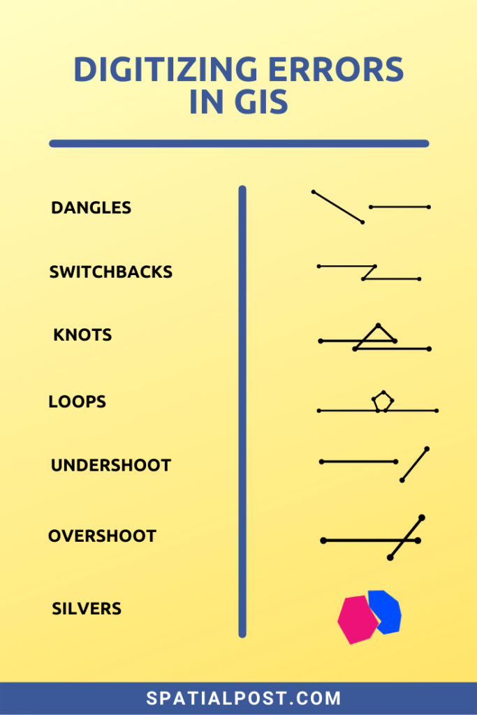
Types of Digitizing Errors In GIS
The process of creating GIS maps typically entails different types of digitizing errors that are present in the final product.
Digitizing errors in GIS is a frequent problem that occurs when the data in a map is captured and translated into a computer file. There are different types of digitizing errors which can be defined as follows:
#1. Geodetic Errors
Geodetic errors occur when we calculate the coordinates of a point or an area using physical measurements instead of due to angles or distances on the earth’s surface.
This leads to inaccurate spatial data which can lead to discrepancies in spatial data that may be important to you or your business
#2. Dangling Nodes
A dangling node is a point that has no connection to the rest of the network.
They are termed “dangling nodes” because they don’t have any connections with other nodes within the system.
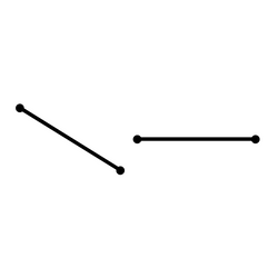
Dangling nodes have been shown to have many consequences which could range from losing track of existing connections in the network, creating wrong paths for routing or navigation, and causing low-quality spatial clustering patterns.
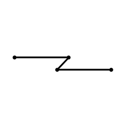
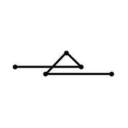
#3. Switchbacks, Knots & Loops
These types of errors occur when the GIS operators digitize polylines with extra vertices or nodes.
In Switchbacks, due to extra vertices, polyline formed with a bend.
With Knots & Loops, the polyline folds back itself to form weird polygons.

#4. Overshoots and Undershoots
Overshoots and undershoots are errors in GIS that arise when the system is trying to find a nearby point of interest.
Overshoot occurs when the system identifies a point of interest too far away from the feature.

On the other hand, an undershoot is where the system identifies a point of interest too close to the feature.

This can cause problems especially if you need to make an informed decision on driving directions or finding out where to go.
#5. Silver Polygon
Silver Polygons are errors formed between adjoining polygons overlapped by any other polygon. This is due to snap tolerance values and only form in polygons.

Digitizing Errors In GIS (Infographics)
Importance of Digitization In GIS
In this day and age, digitizing data is an important process for a GIS. This is due to the fact that the utility of GIS is growing and has become an integral part of our daily lives.
Data digitization is important for GIS professionals who need to convert their digital data into geographic data to work with it.
The first step of a GIS project is to digitize the data that will be collected by the tool. This process is tedious and tedious and time-consuming to build a digital map.
Capturing the data on a GIS usually entails using different types of sensors and GPS. When we move from analogue to digital. The digital process also needs more time than the traditional one due to the enhanced processing power and accuracy of modern computers.
Advantages of Digitizing In GIS
The digital map has become one of the most efficient tools for surveying and analyzing data across industries. From surveying geologists to urban planners, digitizing spatial data has become an essential part of their job.
- It allows managers and staff members to easily access information when needed.
- When there is an update or changes that need to be made to the GIS file, it is often easier for companies to make the edits by importing the digitized data into a PDF or jpg format.
- It also gives decision-makers access to maps in their preferred format such as PDFs and JPEGs when needed.
Summary
Over the last few years, we have seen a huge change in the way we experience and use spatial data. Digitization has made it possible to store and process data at a much faster rate.
Disrupting the traditional GIS environment, a new digital GIS is emerging, digitizing and transforming traditional GIS software to improve efficiency and provide more flexible data input.