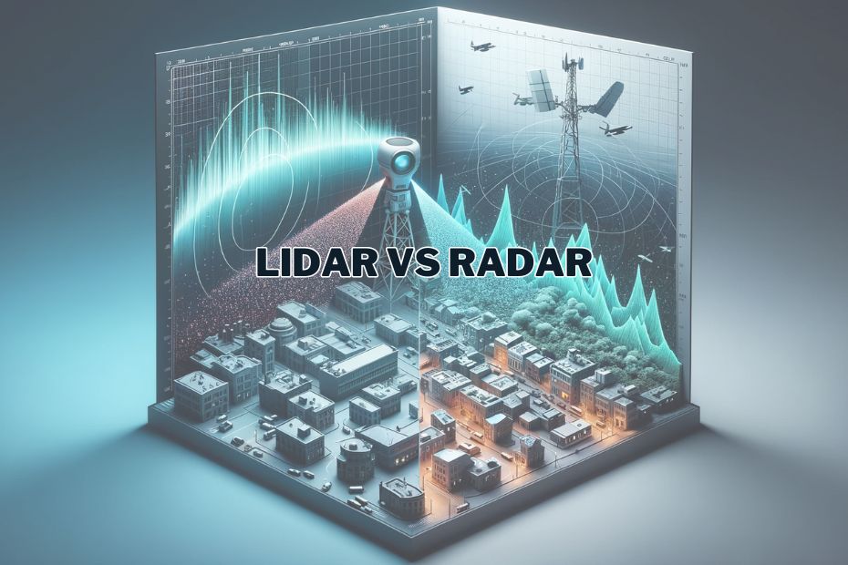
In today’s technologically advanced world, the development of various sensing technologies has paved the way for incredible innovations. Two prominent players in the field of remote sensing are Lidar (Light Detection and Ranging) and Radar (Radio Detection and Ranging). These two technologies are often used interchangeably, but they have distinct characteristics, applications, and advantages. In this article, we will delve into the world of Lidar vs Radar, exploring their differences and the diverse domains in which they find application.
Lidar and Radar are both sensing technologies used for distance measurement and object detection. Lidar, using pulsed laser light, excels in high-precision and detailed imaging, while Radar, utilizing radio waves, performs better in adverse weather conditions and over longer distances. The choice between Lidar and Radar depends on the specific application’s needs for accuracy, range, and environmental resilience.
Key Differences Between Lidar and Radar
In the realm of remote sensing and spatial analysis, two technologies stand out for their unique capabilities and applications: Lidar (Light Detection and Ranging) and Radar (Radio Detection and Ranging). Both technologies have transformed how we perceive and interact with our environment, yet they possess distinct characteristics and uses.
| Aspect | Lidar | Radar |
|---|---|---|
| Technology Type | Optical remote sensing | Radio wave-based remote sensing |
| Precision | Higher precision in object detection and mapping | Less precise compared to Lidar |
| Weather Dependency | Affected by atmospheric conditions like fog and rain | More robust against adverse weather conditions |
| Applications | Topographical mapping, autonomous vehicles, archaeology | Weather forecasting, aviation, military surveillance |
Understanding Lidar Technology
What is Lidar?
Lidar, an optical remote sensing technology, uses light in the form of a pulsed laser to measure distances. This technology creates high-resolution maps of the earth’s surface, making it invaluable in topographical mapping, autonomous vehicle navigation, and even uncovering archaeological sites. Lidar’s precision in object detection and terrain mapping is unparalleled, offering detailed 3D representations of the surveyed area.
How Does Lidar Work?
Lidar operates by emitting laser beams towards a target, which then bounce back to a receiver. By measuring the time it takes for the laser pulses to return, Lidar can calculate the distance to the target with remarkable precision.
Advantages of Lidar
- High accuracy in distance measurement
- Exceptional 3D mapping capabilities
- Ability to penetrate dense vegetation
Applications of Lidar
- Environmental Mapping: Lidar is instrumental in creating detailed topographical maps and assessing forest density for ecological studies.
- Autonomous Vehicles: Lidar is a crucial component in self-driving cars, enabling real-time obstacle detection and navigation.
- Archaeology: It aids in the discovery and preservation of archaeological sites by mapping the terrain in high detail.
- Flood Risk Assessment: Lidar can help predict and mitigate flood risks by accurately mapping elevation data.
However, Lidar is not without its limitations. Its effectiveness is compromised in adverse weather conditions like heavy rain or fog, as these elements can scatter the light pulses.
Exploring Radar Technology
What is Radar?
Radar is a remote sensing technology that uses radio waves to detect and locate objects. It has been a pivotal technology in various fields, including aviation, meteorology, and military applications.
How Does Radar Work?
Radar sends out radio waves, which bounce off objects and return to the radar receiver. By analyzing the time it takes for the waves to return and their frequency shifts, Radar can determine the object’s distance, speed, and size.
Advantages of Radar
- Effective in all weather conditions
- Long-range detection capabilities
- Pervasive use in aviation and defense sectors
Applications of Radar
- Weather Forecasting: Radar is indispensable for monitoring weather patterns, including precipitation, thunderstorms, and hurricanes.
- Air Traffic Control: It ensures the safe navigation of aircraft, preventing collisions in busy skies.
- Military Surveillance: Radar plays a vital role in defense, tracking aircraft, ships, and missiles.
- Ground Penetrating Radar (GPR): Used in civil engineering to detect underground utilities and voids.
Continue reading about Lidar’s effectiveness at night
Learn more about Lidar vs. Photogrammetry
Discover the differences between active and passive sensors in remote sensing
Lidar vs Radar: The Key Differences
Now that we’ve explored the fundamentals of Lidar and Radar, let’s break down their essential differences:
Technology
- Lidar uses laser pulses.
- Radar employs radio waves.
Accuracy
- Lidar offers higher accuracy in distance measurement.
- Radar provides coarser distance measurements but excels in long-range detection.
Weather Sensitivity
- Lidar performance can be affected by adverse weather conditions, such as fog or heavy rain.
- Radar is highly reliable in all weather conditions.
Penetration
- Lidar struggles to penetrate solid objects but excels at mapping surfaces.
- Radar can penetrate obstacles like clouds and foliage but has limited surface mapping capabilities.
Cost
- Lidar systems are generally more expensive due to their intricate laser technology.
- Radar systems are often more cost-effective.
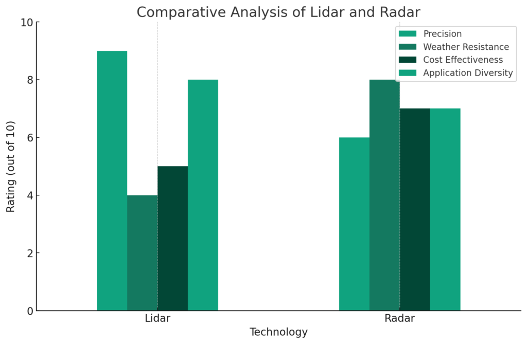
- Precision: Lidar scores higher, indicating its superior accuracy in mapping and object detection.
- Weather Resistance: Radar outperforms Lidar, showcasing its effectiveness in diverse weather conditions.
- Cost Effectiveness: Radar is more cost-effective compared to Lidar, making it a more viable option for a wider range of applications.
- Application Diversity: Lidar has a slightly higher score, reflecting its versatile use in different fields like urban planning, autonomous vehicles, and archaeology.
Choosing the Right Technology
The choice between Lidar and Radar depends on the specific application and requirements. While both technologies have their strengths, selecting the appropriate one ensures the success of a project.
Comparative Analysis: Operational Differences
When choosing between Lidar and Radar for a specific application, understanding their operational differences is crucial. Lidar, with its laser-based technology, excels in creating detailed 3D models of the environment. This precision makes it ideal for applications requiring high-resolution data, such as urban planning and detailed environmental assessment.
Lidar’s Strengths and Limitations
- Strengths: High-resolution data, accurate distance measurement, effective in clear weather conditions.
- Limitations: Poor performance in fog, rain, or clouds, higher cost compared to Radar.
In contrast, Radar, while less precise, offers consistent performance in various weather conditions. Its ability to penetrate clouds and rain makes it indispensable for meteorological applications and long-range detection tasks.
Radar’s Strengths and Limitations
- Strengths: Weather-resistant, long-range capabilities, suitable for large-scale surveillance.
- Limitations: Lower resolution data, less effective for fine-scale mapping.
Technology Advancements and Future Prospects
Recent advancements in both Lidar and Radar technologies are expanding their capabilities and applications. For instance, the development of more compact and affordable Lidar systems is making this technology more accessible for smaller-scale projects and consumer applications.
Future of Lidar:
- Autonomous Driving: Enhanced obstacle detection and navigation systems.
- Environmental Monitoring: More detailed and frequent data collection.
The evolution of Radar technology is also noteworthy. Improved signal processing and enhanced resolution are making Radar more versatile, especially in applications like autonomous navigation and industrial monitoring.
Future of Radar:
- Drone Technology: Improved aerial mapping and surveillance.
- Industrial Applications: Enhanced monitoring in manufacturing and construction sectors.
As we move forward, the integration of Lidar and Radar technologies could offer a synergistic approach, combining the strengths of both to provide comprehensive data for various applications. This integration is particularly promising in fields like autonomous vehicles, where the combination of Lidar’s precision and Radar’s weather resilience can significantly enhance safety and efficiency.
Conclusion:
In conclusion, Lidar and Radar are invaluable tools in remote sensing, each with its unique capabilities and applications. Understanding their differences empowers decision-makers to make informed choices, advancing fields ranging from autonomous vehicles to weather forecasting.
FAQs: Lidar Vs Radar
Is Lidar better than Radar for self-driving cars?
The choice depends on the desired level of accuracy and the budget of the project. Lidar offers high precision but is costlier, while Radar provides long-range detection at a lower cost.
Can Radar be used for archaeological purposes?
Radar is less suitable for archaeological applications due to its limited surface mapping capabilities. Lidar is generally preferred for such purposes.
Are there any hybrid systems combining Lidar and Radar?
Yes, some applications benefit from combining Lidar’s detailed mapping with Radar’s long-range detection. These hybrid systems offer enhanced capabilities.
Can Lidar be used in military surveillance?
While Lidar is primarily used for mapping and environmental purposes, Radar is the technology of choice for military surveillance due to its long-range capabilities and weather resilience.
Which technology is more commonly used in weather forecasting?
Radar is the primary technology used in weather forecasting, as it can accurately detect precipitation and track storms in real-time.